infrared.city: Comprehensive Microclimate Modeling & Thermal Comfort Software
Advanced Thermal Comfort Assessment
Thermal Climate Index (TCI) Model
infrared.city implements the internationally standardized UTCI (Universal Thermal Climate Index) methodology, which represents outdoor thermal comfort through an equivalent temperature approach. This comprehensive approach integrates a multi-node thermo-physiological model coupled with adaptive clothing algorithms that dynamically adjust insulation values based on outdoor temperature conditions.
Core Capabilities:
- Real-time calculations based on current environmental conditions
- Advanced thermo-physiological modeling with international standard compliance
- Comprehensive integration of air temperature, humidity, wind speed, and radiation
- Spatially-resolved thermal comfort maps showing equivalent temperature values
Thermal Model Schema Approximation
Thermal Stress Classification System
The UTCI methodology categorizes thermal conditions into nine distinct stress levels, enabling precise quantification of environmental performance:
- Extreme cold stress: < -40°C
- Very strong cold stress: -40°C to -27°C
- Strong cold stress: -27°C to -13°C
- Moderate cold stress: -13°C to 0°C
- Slight cold stress: 0°C to 9°C
- No thermal stress: 9°C to 26°C (target range)
- Moderate heat stress: 26°C to 32°C
- Strong heat stress: 32°C to 38°C
- Very strong heat stress: 38°C to 46°C
- Extreme heat stress: > 46°C
UTCI: Thermal Stress Categories
UTCI Parameter Correlations and Interdependencies
The software accounts for complex interdependencies between environmental factors that significantly influence thermal perception. Understanding the correlations between UTCI input parameters is crucial for accurate urban-scale calculations.
infrared.city provides real-time assessment of human thermal comfort in outdoor environments through physiologically-based modeling, validated through extensive human subject studies across diverse climate zones worldwide. It integrates multiple environmental factors into a single index that represents how the environment actually feels to the human body.
The model performs detailed geometric analysis to determine sky visibility and solar exposure at each analysis point, calculating Mean Radiant Temperature by integrating both solar radiation and thermal radiation from surrounding surfaces. Environmental parameters are processed through a multi-node human heat balance model that simulates dynamic human responses including sweating, shivering, and blood flow regulation.
Air Temperature vs. Mean Radiant Temperature
Air temperature and Mean Radiant Temperature exhibit strong correlations that vary with urban morphology - e.g. in dense urban canyons, MRT can exceed air temperature by 20-30°C during sunny conditions due to solar absorption and thermal re-radiation from building surfaces. Conversely, in open spaces with high sky view factors, MRT may be lower during clear nights due to radiative cooling.
Wind Velocity Effects
Wind velocity shows strong negative correlation with UTCI values, particularly at higher temperatures. A 1 m/s increase in wind speed can reduce UTCI by 3-5°C in hot conditions. However, this cooling effect diminishes at very low temperatures where wind increases convective heat loss.
Humidity Interactions
Vapor pressure affects UTCI primarily through its impact on evapotranspiration cooling. The relationship is non-linear, with humidity effects becoming more pronounced at higher air temperatures when human thermoregulation relies heavily on sweating.
Sensitivity Study: Two-at-a-time sensitivity analysis of the UTCI input variables Source: Konsgaard, J., Møller, B. J., Kristensen, P. R., Jensen, K. C., & Jensen, T. O. (2016). A sensitivity study of the Universal Thermal Climate Index (UTCI). Building and Environment, 109, 1–11.
Thermal Comfort Statistics (TCS) Model
The TCS engine transforms point-in-time comfort analysis into comprehensive long-term performance insights by processing a full year of hourly climate data. This statistical framework reveals patterns of thermal performance essential for strategic planning and design validation.
The software systematically processes 8,760 hourly data points annually, calculating UTCI values and categorizing them into comfort ranges. Statistical aggregation determines how frequently thermal stress conditions occur at each location, with advanced filtering capabilities enabling focus on critical periods such as summer afternoons or winter mornings.
Statistical Analysis Features:
- Annual time-series analysis processing complete yearly datasets
- Quantitative risk assessment through frequency analysis
- Flexible temporal filtering by season, month, or time of day
- Percentage-based performance maps showing heat stress, cold stress, and comfort frequency
Thermal Comfort Statistics: Thermal Comfort, Heat Stress, Cold Stress
Comprehensive Radiation Physics
Shortwave Radiation Modeling
infrared.city implements sophisticated solar radiation calculations accounting for direct solar irradiance, diffuse sky radiation, and reflected radiation from surrounding surfaces. The software processes geometry through advanced ray-tracing algorithms to determine solar exposure patterns throughout the day and across seasons.
Sky View Factor calculations utilize the Tregenza sky subdivision method with 145 discrete sky patches, providing precise quantification of visible sky portions at each analysis point.
Source: P. R. Tregenza. (1987). Subdivision of the sky hemisphere for luminance measurements. Lighting Research & Technology, 19(1):13-14. Source: Ashdown, I. (2016). Climate-Based Daylight Modeling From Theory to Practice.
On the left, coverage of the sky with 151 circular patches and on the right, Tregenza Sky Subdivision, wherein the sky dome is subdivided into eight 12-degree horizontal bands with 145 sky patches (Tregenza, 1897).
He observes that “The disadvantages are that the increment of azimuth between adjacent zones varies between altitude bands, and that the proportion of the sky covered by patches also varies slightly. These are characteristic of any geometric subdivision of a hemisphere into zones of equal area within parallel bands. A small improvement of total coverage, to 75%, can be achieved with a 12° acceptance angle, provided that some bands contain an odd number of zones; but this removes symmetry across one vertical plane. Alternatively, reducing the number of zones from 32 to 30 in band 1, and from 28 to 24 in band 3, gives a 3-way symmetry overall. The azimuth increment is then always an integer, but the total coverage is reduced to 68%, with greater unevenness.” So this is how we ended up with 145 zones of 12 degree diameter.
Moreover, surface-specific albedo properties enable accurate modeling of reflected shortwave radiation, capturing how different materials contribute to the overall radiant environment.
The integration of real solar position data with site geometry ensures that shadowing effects from buildings, vegetation, and topography are precisely calculated for any location and time period.
Longwave Radiation Physics
Longwave thermal radiation modeling incorporates Stefan-Boltzmann principles to calculate radiative heat exchange between surfaces and the atmosphere. infrared.city computes surface temperatures based on material properties, solar exposure, and ambient conditions, then determines radiative flux contributions to Mean Radiant Temperature through view factor weighting.
The software distinguishes between air temperature and effective sky temperature, where sky temperature represents the thermal radiation exchange between Earth’s surface and the atmospheric column, accounting for water vapor, cloud effects, and radiative cooling to outer space. This distinction proves critical for accurate nighttime thermal comfort assessment when radiative cooling effects can significantly reduce apparent temperatures below air temperature values.
The software implements Direct Mean Radiant Temperature (DMRT) calculations using Effective Radiant Field (ERF) methodology to quantify thermal effects of solar radiation absorbed by the human body. This approach separates diffuse sky radiation from direct beam solar radiation, accounting for the projected area relative to sun position and human body orientation.
Atmospheric longwave radiation is modeled using established correlations with air temperature and humidity, while surface-to-surface radiation exchange accounts for complex urban geometry. This comprehensive approach ensures both daytime solar heating and nighttime radiative cooling effects are accurately represented in thermal comfort calculations.
Source: Lenzholzer, S. (2015). Weather in the City – How Design Shapes the Urban Climate. Rotterdam: nai010 publishers.
AI-Powered Wind Analysis
Wind Speed (WS) Model
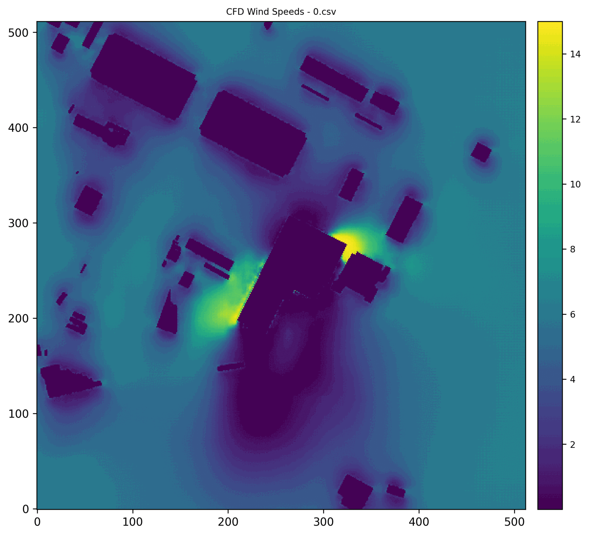
infrared.city revolutionizes wind analysis through AI-powered prediction delivering CFD-quality results in seconds, rather than hours. The breakthrough technology employs machine learning surrogate models trained on thousands of computational fluid dynamics simulations across diverse urban environments, achieving CFD-equivalent accuracy with correlation coefficients exceeding 0.95.
The trained models have learned complex relationships between urban geometry and wind flow patterns, enabling instant prediction of detailed velocity fields for any building configuration and wind condition. This approach combines the speed needed for design iteration with the accuracy required for engineering decisions.
Wind Analysis Capabilities:
- AI-powered predictions with 100-1000x faster processing than traditional CFD
- CFD-equivalent accuracy maintaining research-grade precision (R² > 0.95)
- Real-time responsiveness enabling iterative design optimization
- Comprehensive flow visualization showing acceleration zones, stagnation areas, and downdrafts
Source: Kabošová, L., Chronis, A., Galanos, T., Kmeť, S., & Katunský, D. (2022). Shape optimization during design for improving outdoor wind comfort and solar radiation in cities. Building and Environment, 226.
Status quo wind flow simulation. Left - InFraRed prediction of the win flow in the 2.5x2.5 km zone. Right - Procedural Compute CFD analysis of the same zone 1.75m above the ground. “A” - accelerated flow, “T” - turbulent flow.
Pedestrian Wind Comfort (PWC) Model
The PWC engine provides comprehensive annual wind comfort assessment using advanced statistical methods accounting for the full variability of local wind patterns - built on robust Weibull probability distribution framework. This model delivers regulatory-compliant analysis for planning approval and safety validation, incorporating international standards including Lawson LDDC, General Lawson, Davenport, and NEN 8100 criteria.
infrared.city analyzes site-specific wind data to establish probability distributions for each wind direction, then calculates exceedance probabilities - the likelihood that wind speeds will exceed comfort thresholds - weighted by the frequency of winds from each direction. Results are classified according to international comfort standards to produce clear, defensible comfort ratings.
Wind Comfort Features:
- Probabilistic methodology using established Weibull distribution modeling
- Full annual assessment incorporating directional wind frequency patterns
- International standards compliance with Lawson, Davenport, and NEN 8100 criteria
- Wind comfort classification maps with statistical validation for regulatory compliance
Using Weibull distribution for calculating pedestrian wind comfort, based on Lawson Criteria
The Weibull Distribution is a two-parameter probabilistic model commonly used to represent wind speed variability. This method is particularly suited for wind comfort and safety analyses, as it accounts for the asymmetric and variable nature of wind speed data. By fitting a Weibull distribution to site-specific wind records (e.g., from EPW files), it is possible to obtain a continuous representation of wind speed probability.
This statistical model allows for:
- Robust estimation of exceedance probabilities across comfort thresholds
- Integration with directional wind frequency data
- Site-specific adaptation to local climate and terrain conditions
In urban applications, the Weibull distribution supports annual comfort assessments by providing a probabilistic framework to evaluate how often wind conditions may cause discomfort or exceed safe limits.
Advanced Vegetation Modeling
Current Geometric Capabilities
infrared.city enables real-time parametric control over tree placement, species selection, and morphological characteristics through a comprehensive species database covering broadleaved, needleleaved, and leafless vegetation types. The software implements species-specific parameters including height ranges and crown diameters
The vegetation feature processes geometry as three-dimensional objects that cast shadows and block solar radiation according to specified characteristics, with species databases providing realistic crown shapes for different tree types. Integration with the UTCI calculation engine ensures vegetation shading effects are immediately reflected in thermal comfort metrics through validated geometric modeling approaches.
| Species | Translated English Name | Height (m) | Height Range per Species (m) | Crown Diameter (m) | Crown Diameter Range per Species (m) | LeafType | LeafCycle |
|---|---|---|---|---|---|---|---|
| Quercus robur | English oak | 25 | 20 To 30 | 20 | 15 To 25 | Broadleaved | Deciduous |
| Quercus ilex | Holm oak | 15 | 12 To 18 | 18 | 15 To 20 | Broadleaved | Evergreen |
| Combretum collinum | Bushwillow | 10 | 8 To 15 | 10 | 8 To 12 | Broadleaved | Semi-deciduous / Semi-evergreen |
| Larix decidua | European larch | 30 | 25 To 35 | 20 | 15 To 25 | Needleleaved | Deciduous |
| Pinus pinea | Stone pine | 20 | 15 To 25 | 25 | 20 To 30 | Needleleaved | Evergreen |
| Taxodium distichum | Bald cypress | 30 | 25 To 35 | 18 | 15 To 22 | Needleleaved | Semi-deciduous |
| Cupressus sempervirens | Mediterranean cypress | 25 | 20 To 30 | 6 | 4 To 8 | Needleleaved | Semi-evergreen |
| Euphorbia tirucallidis | Pencil tree | 7 | 5 To 10 | 8 | 5 To 10 | Leafless | Evergreen / Semi-deciduous / Deciduous |
Available Trees Species and Characteristics Database Overview
Radiative Effects Implementation
Vegetation elements modify the radiative environment through multiple established mechanisms implemented via advanced ray-tracing analysis. The software employs Radiance-based ray-tracing algorithms to calculate precise solar radiation interception by tree canopies.
infrared.city’s ray-tracing engine processes vegetation as three-dimensional geometric objects within the broader site analysis, calculating filtered radiation reaching ground surfaces and pedestrian levels beneath tree canopies. This approach ensures accurate shadow casting and solar exposure modification accounting for canopy geometry, tree positioning, and seasonal sun angles.
Longwave radiation exchange is modified by vegetation surfaces through the same ray-tracing methodology, accounting for view factor modifications and thermal radiation interception. Tree canopies operating at different temperatures than built surfaces create localized mean radiant temperature modifications that are precisely calculated through geometric radiation analysis rather than simplified assumptions.
infrared.city calculates filtered radiation reaching ground surfaces and pedestrian levels beneath vegetation using established radiative transfer principles. Longwave radiation exchange is modified by vegetation surfaces, which typically operate at different temperatures than built surfaces, creating localized modifications to the mean radiant temperature field through validated thermal modeling approaches.
Tree canopies intercept both incoming atmospheric radiation and outgoing surface radiation, with the software implementing species-specific thermal characteristics based on extensive botanical research covering temperate, subtropical, and arid climate zones.
Vegetation Analysis Features:
- Real-time parametric control with species-specific parameters
- Geometric shading and solar radiation interception modeling
- Integration with thermal comfort calculations
- Instant KPI comparison with and without vegetation scenarios
Parametrical placing of Trees through infrared.city grasshopper plugin
Material and Vegetation Data Parsing from OSM
The system enables large-scale analysis through integration with OpenStreetMap (OSM) data parsing for automated trees identification, providing seamless workflow from urban planning scales to detailed microclimate analysis.
Validation and Performance
Research Foundation
The software incorporates validated research methodologies from multiple domains including thermal comfort science, urban climatology, and computational fluid dynamics.
Wind comfort assessment implements established statistical methods validated through international standards compliance, while thermal comfort calculations utilize internationally standardized UTCI methodology with extensive validation across climate zones.
Current Model Accuracy
infrared.city’s radiation modeling demonstrates high accuracy for solar exposure and shadowing calculations. Wind analysis maintains CFD-equivalent performance with correlation coefficients exceeding 0.95 when compared to full computational fluid dynamics simulations.
UTCI calculations follow international standards and have been cross-validated against reference implementations across diverse climate conditions using established comfort thresholds
The statistical analysis framework provides robust annual performance assessment capabilities based on established meteorological data processing methods, incorporating validated KPI calculation approaches with international standard compliance verification.
Validation and quality assurance. Image-to-Image analysis
Current Modeling Limitations
The software prioritizes established, well-validated physical processes while clearly communicating areas where additional development will enhance accuracy and expand modeling capabilities. These limitations are well-understood and inform development priorities for enhanced vegetation physics in future releases. This approach ensures reliable performance for current applications while providing a clear path for enhanced functionality.
UTCI Integration Status: Parameter Correlation Modeling
While infrared.city currently implements advanced radiation modeling and geometric analysis components of UTCI methodology, complete wind integration within the UTCI calculation framework is scheduled for next Phase of development. Current wind analysis capabilities operate as separate assessment tools providing pedestrian comfort evaluation, but full integration of wind effects into thermal comfort index calculations awaits upcoming development phases.
The current implementation employs simplified approaches to environmental parameter interactions, with advanced sensitivity analysis and environmental feedback loop modeling planned for future development. Complex correlations between air temperature, humidity, and wind effects on thermal sensation are not yet fully integrated into the computational framework.
Vegetation Physics
While infrared.city captures geometric shading effects with high accuracy, evapotranspiration processes are not currently incorporated. Latent heat removal through leaf transpiration, which can reduce local air temperatures even by 2-8°C, represents a significant cooling mechanism not yet modeled. Vegetation-induced humidity increases and their feedback effects on thermal comfort calculations are not included in the actual version. Also, wind models don’t actually account for trees, as they don’t compute them as obstacles.
Seasonal variations in leaf area index, species-specific transpiration rates, and soil moisture interactions remain areas for future development. The current approach provides conservative estimates of vegetation benefits, focusing on well-established radiative effects while acknowledging additional cooling potential from transpiration processes.
Additional Microclimate Factors
infrared.city currently focuses on primary drivers of outdoor thermal comfort - solar radiation, air temperature, humidity, and wind (as separate asset) - while several secondary microclimate factors await future integration. Water features such as fountains and misting systems, anthropogenic heat sources from traffic and HVAC systems, and ground surface moisture effects represent additional influences on local climate conditions.
Urban heat island intensity variations and their spatial distribution across different urban morphologies are not explicitly modeled, though the software captures many underlying physical processes contributing to these phenomena.
Technical Architecture
Computational Framework
infrared.city employs distributed machine learning architectures to overcome traditional barriers of long simulation times and high processing costs. The hybrid workflow combines high-resolution environmental simulations with trained surrogate models, enabling rapid and consistent analysis without extensive time-consuming simulations for every data point.
The multi-step calculation process incorporates validated optimization techniques including mesh interpolation studies for performance enhancement and geometry-performance sensitivity analysis across building typologies. Computational efficiency improvements include interpolated analysis methods drastically reducing simulation times. As previously mentioned, the calculation process begins with Sky View Factor computation using geometric and radiative methods, followed by Mean Radiant Temperature calculation accounting for both shortwave and longwave radiation. Finally, all meteorological inputs are processed through thermo-physiological models to provide comprehensive thermal comfort assessment.
Sensitivity study of various geometric variations in building typologies and their impact on environmental performance.
Advanced Simulation Methodology
The computational framework implements Two-Phase simulation methodology that separates geometric relationship calculations from dynamic weather condition integration. This approach enables efficient annual UTCI analysis by pre-computing view factors and solar relationships, then dynamically integrating hourly weather data without repetitive geometric calculations.
EPW Climate Data Quality Assurance
The climatic dashboard addresses comprehensive climate data validation, having implemented EPW sanity check protocols to ensure data quality and file selection prioritization. The system has incorporated TMYx file prioritization, airport weather station preference, and comprehensive data integrity validation covering temperature variance analysis, humidity range verification, and radiation consistency checks -among others - across all 8760 annual hours.
- Knowledge Base